Announcement

Collapse
No announcement yet.

Tides vs Currents - What's the difference

Collapse
X
 
  • Filter
  • Time
  • Show
Clear All
new posts

  • Tides vs Currents - What's the difference

    Learning how to effectively fish the tides and resulting currents has been a challenge for me over the past year. I am getting better at it, but I still have a long way to go. I realize that, at the end of the day, I need to be able to fish whatever conditions are occurring when I find a window to fish in. Knowing what all the variables are ahead of time, however, can make the time on the water as effective as possible.

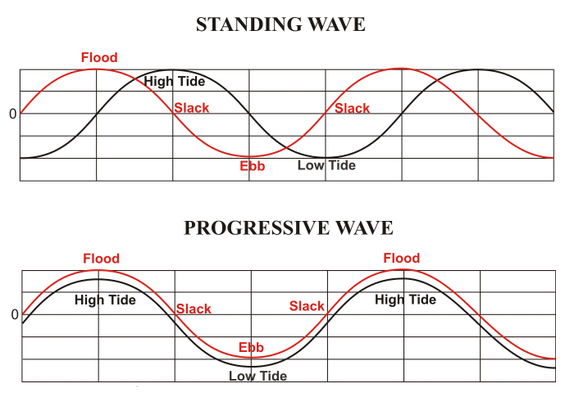
    I was poking around the web looking for some current prediction charts and I stumbled across this excellent presentation, by Cap't Sean Crawford, breaking down the hows and whys of tides and currents and how they effect our fishing in the region. I found it very interesting, and you might as well.

    http://www.terrapinbayfishing.com/up...on_Fishing.pdf

    NOAA also has current prediction charts that include more near time data. They can be found at:

    https://tidesandcurrents.noaa.gov/po...&mode=allwater
    Bruce

    Hobie PA 14
    Wilderness System, Thresher 155

  • #2
    This is a good topic to cover because it can be tough to understand for those who have had limited time on the water.

    Tides4Fishing has a feature called the tidal coefficient. This is a numerical value assigned to the speed of the current. A high coefficient (>75) typically occurs around the same time as a new or full moon and means you are going to have a strong current. The day of the full or new moon can be as high as >100. This is because the amount of water (or tide) between high and low is greater during these times. Because each tide is always 6 hours apart, you need more current to fit the increased amount of water into the same timeframe. Current is not as big of an issue the further you travel away from the main stem of the bay. The closer you are to the source, the more impacted you and the fish will be.

    NOAA also has another feature for tides and current. This shows you "max incoming", "slack", and "max outgoing" current. When you get near the coastal areas such as the CBBT or other seaside inlets, the tide runs about 2 hours being the current; meaning that sometimes you will have a low tide, even though the current is still moving in. The further you are from the coastal inlets the less discrepancy you will see between the posted tide times and current direction. If I am fishing areas like the CBBT or OC, I look at the current direction and speed. If I am fishing northern areas such as Crisfield, I fish the posed tide times.
    ___________________________

    Hobie Fishing Team Member
    Survival Products, Salisbury, MD

    2017 Camo Hobie Outback
    2015 Olive Hobie Outback

    Comment


    • #3
      I may be way off but I thought in rivers or bays that the slack current will always be behind the tide. I remember reading something along these lines; picture the tide as a a wave that will be passing you. As the wave reaches your location it is high tide. The wave will keep traveling further upriver and pulling water in behind it and there will still be an incoming current. Hence slack current will come in sometime behind high tide. Vice versa for outgoing.

      It seems to hold true for me at most of the locations that I fish. I know there are many many other variables depending on your location but am I generally right on this?

      Comment


      • #4
        That analogy makes sense. You will still have incoming current past the posted high tide time in some places, especially those closer to the coast. The tide will sometimes switch to an outgoing, despite the incoming current. For example the posted high tide for the 1st island of the CBBT for March 18th is 5:38 AM, but there max incoming current is not until 7:41 AM. The slack current is 10:22 AM, meaning your "wave" of incoming current will continue long after the peak water level/high tide. This is an extreme case because it is right at the mouth of the bay, but to some extent, this will exist most places on the bay.
        ___________________________

        Hobie Fishing Team Member
        Survival Products, Salisbury, MD

        2017 Camo Hobie Outback
        2015 Olive Hobie Outback

        Comment


        • #5
          It's been a while since I did any reading on this and I remember watching a very nice video explaining it all. To really get into the details I think you need a doctorate. Can't find the video now of course now that I want it.

          Current is definitely something to consider as you can see in this chart showing kayak speed in various currents and conditions. Believe this chart is from the video I mentioned.
          500.jpg
          Simple trip out can become an ordeal or impossible on the way back and you may just have to wait it out.

          What kind of baffles me is how tides effect currents in areas such as Wachapreague and other coastal bays. With multiple various inlets and channels running east west and north south and every which way, seems some funny stuff could happen with currents. It gets to much for my mind to try to picture where and how strong a current is going to be with a tide in those type of areas.

          Comment


          • #6
            Isn't current, really a resul t of a specific local underwater topography, that varies in speed direction with tide? I always felt that current was something I could only effectively consider in my fishing plan if I was very familiar with the water or has local intel

            Sent from my SM-G360V using Tapatalk
            14.5 ft Sand colored Malibu X-Factor "the promise"
            2010 Hobie Outback "the Gift Horse II"

            Comment


            • #7
              Originally posted by kevinfry View Post
              Isn't current, really a resul t of a specific local underwater topography, that varies in speed direction with tide? I always felt that current was something I could only effectively consider in my fishing plan if I was very familiar with the water or has local intel
              You are absolutely right. I guess a better term, about what I think I have been trying to talk about, would be tidal currents or tidal flow and how they work in general. You are absolutely right as to how a tidal flow will interact with any particular body of water, you better be very familiar and have the intel.
              Think that is the wall I'm running into when I try to imagine how an incoming tide is going to effect currents when looking at Wachapreague. Familiarity, knowledge and intel is going to be my only help and general theories could get me in trouble.

              Comment


              • #8
                Yeah..but should be fun testing you theories. I love.fishing new water, even though it is often in productive as you learn a new place

                Sent from my SM-G360V using Tapatalk
                14.5 ft Sand colored Malibu X-Factor "the promise"
                2010 Hobie Outback "the Gift Horse II"

                Comment


                • #9
                  My Grandfather taught me many years ago that a following current is on the average 6 hours behind a tide change depending on the moon in most cases and in most tidal waters. Since I predominately fish the salt, and prior to becoming addicted to kayak fishing, I fished the surf. The only thing to worry about fishing from the beach is the wind and the tide. When I first purchased my yak I had to explore a VA barrier island. Not a good decision because I did not remember my grandfathers statement. I planned my trip on the tides and on the return almost got swept out to sea because of the currents. As I was battling the opposing current and wearing out quickly, a local in a Jon boat pulled up beside me and said, SON, you should wait for the current to flatten out. That is when I remembered my Grandfathers statement. He offered me a tow for the next 2 miles and I accepted. He towed me to an area that was not influenced by the flow and said wait a few hours and you wont have a problem getting back to the launch. He was right.

                  So here is my question, We have all this technology at our disposal today so how back in the late 50s early 60s did they know what we know today?
                  Freddie T

                  2016 Hobie Outback LE #236
                  Torqeedo Ultralight 403

                  Comment


                  • #10
                    Originally posted by Salty Dog View Post
                    My Grandfather taught me many years ago that a following current is on the average 6 hours behind a tide change depending on the moon in most cases and in most tidal waters. Since I predominately fish the salt, and prior to becoming addicted to kayak fishing, I fished the surf. The only thing to worry about fishing from the beach is the wind and the tide. When I first purchased my yak I had to explore a VA barrier island. Not a good decision because I did not remember my grandfathers statement. I planned my trip on the tides and on the return almost got swept out to sea because of the currents. As I was battling the opposing current and wearing out quickly, a local in a Jon boat pulled up beside me and said, SON, you should wait for the current to flatten out. That is when I remembered my Grandfathers statement. He offered me a tow for the next 2 miles and I accepted. He towed me to an area that was not influenced by the flow and said wait a few hours and you wont have a problem getting back to the launch. He was right.

                    So here is my question, We have all this technology at our disposal today so how back in the late 50s early 60s did they know what we know today?
                    I think I may have read the story of your ordeal in another thread and it struck fear in my heart, I think rightly and smartly so.

                    When I mention trying to figure out the currents at Wachapreague it was with the intent of fishing some barrier island bays on trip to the VA Eastern shore. I did have a little trip planned at Gargatha and do believe I had gained enough intel to be safe but it was still worrisome. The weather ended up horrendous and I never did get out. I did do a good bit worrying and a lot of reading but still didn't feel very comfortable venturing out into those bays without having someone around with knowledge of the area.

                    Comment


                    • #11
                      Don,
                      Dont overthink it too much. If you want to be extra cautious, plan your first trip away from the new or full moon when the current is not strong. I fish the mouth of the bay, ESVA, and the barrier islands almost exclusively and with proper planning have not had a scary experience. It is easy to be scared away from these areas and caution is needed, but they are very fishable. If you would like some local knowledge, send me a PM when you are heading down and I'll join you if I am free.
                      ___________________________

                      Hobie Fishing Team Member
                      Survival Products, Salisbury, MD

                      2017 Camo Hobie Outback
                      2015 Olive Hobie Outback

                      Comment


                      • #12
                        This is all great info that ANY kayaker needs, and to be honest wish I had last summer. I have surf fished and been on the pier so I was use to reading tide times.. But like others forgot the current runs after the tide time. After fishing the last hour of the incoming tide i was hoping the current would pull my friend and I back info ocean citys back bay....long story short I was paddling my butt off in a ride 115 mind you trying to get back to the inlet. Now when I fish near the ocean I always will remember to check the current and not tide. (also to bring a better kayak suited for the job) lesson learned luckily no harm.

                        Sent from my LGLS990 using Tapatalk
                        Tan-Tarpon 140
                        Lime-Pelican Matrix
                        Yellow-Scrambler XT

                        Comment


                        • #13
                          Originally posted by RavensDfense View Post
                          Don,
                          Dont overthink it too much. If you want to be extra cautious, plan your first trip away from the new or full moon when the current is not strong. I fish the mouth of the bay, ESVA, and the barrier islands almost exclusively and with proper planning have not had a scary experience. It is easy to be scared away from these areas and caution is needed, but they are very fishable. If you would like some local knowledge, send me a PM when you are heading down and I'll join you if I am free.
                          Thanks I really appreciate the offer and am dying to get back to the area and hope I can take you up on it.
                          Had a whole week near the end of last September and the wind ran about 30 mph all week on the Chesapeake Bay and the ocean side was even worse. Two to three foot wind driven waves were running past Garagatha Landing. Wasn't quite the day to allay my fears but do have to say at the same time it was just so damn beautiful and I am hoping I can get the opportunity to fish it.

                          Comment


                          • #14
                            I keep the following on the VA forum for my fishing needs. With all info about (wind, current and tide) from the web sites I use, I make my trip plans for where to fish, when to launch, When to move to a new spot, and target species. Tide and current info is very important to me when I fish CBBT, CHSP, Rudee, Elizabeth River, Lynheaven and Wise Point (near Kipto). Depending on the fish, the bites are better in low tide, high tide, slack tide, incoming current or outgoing current. In some places, a Hobie with the Pedal Drive can get stuck in the low tide. Also the currents are very strong in some places so I avoid coming back against the current after a whole day fishing.

                            Notes for me for CBBT and CHSP fishing. (Use "progressive wave" model)

                            http://tidesandcurrents.noaa.gov/faq4.html
                            http://fishcurrents.com
                            http://http://www.ndbc.noaa.gov/maps/Chesapeake_Bay.shtml
                            //https://tidesandcurrents.noaa.gov/tide_predictions.html
                            http://www.ndbc.noaa.gov/
                            CHSP http://www.ndbc.noaa.gov/station_page.php?station=LWSD1
                            CBBT http://www.ndbc.noaa.gov/station_page.php?station=cbbv2


                            What is the relationship between "Tides" and "Tidal Currents"?
                            Comparison of tidal conditions vs. tidal current phases
                            The vertical rise and fall of the tides, created by the gravitational force of the Moon and Sun acting on the oceans water, also creates a horizontal motion of the water in the bays, harbors and estuaries. These are tidal currents. In general, as the tides rise there will be a current flowing from the oceans into the bays, harbors and estuaries; this is termed a "flood current". As the tides fall there will be a current flowing towards the oceans; this is termed an "ebb current". There are also periods when there is little or no horizontal motion of the water; this is called "slack water".

                            Many professional and recreational users of tide and tidal current information have a "rule of thumb" to assume a relationship between the times of high/low tides and the times of the currents. That the times of slack water will be at the same time as the high and low tides, and that the flood and ebb current will occur between the high and low tides. Unfortunately, this assumed "rule of thumb" does not hold for most locations.

                            The relationship between the times of high/low tide and the times of slack water or maximum current is not a simple one. There are three "base case" conditions. The first is a "standing wave" type of current. In a standing wave the times of slack water will be nearly the same time as the high and low tides, with the maximum flood and ebb current occurring mid way between the high and low tides. The second is a "progressive wave" current. In a progressive wave, the maximum flood and ebb will occur around the times of the high and low tides, with the slack water occurring between the times of high and low tide. The third case is a "hydraulic current". In a hydraulic current, the current is created by the difference in height of the tides at two locations joined by a waterway. The current will be at its maximum flood or ebb when the difference in the two heights are the greatest. The slack water will occur when the height of the tide at the two locations in nearly the same.

                            Hydraulic currents occur at a limited number of locations. Some examples would be:
                            •the Chesapeake and Delaware Canal, which connects the Chesapeake Bay and Delaware Bay
                            •the East River in New York, which connects Long Island Sound to New York Harbor
                            •certain sections of the Intra Coastal Water Way (ICWW)
                            •between barrier islands which create different tidal conditions on opposite sides of the island

                            Progressive currents are most common at the oceanic entrance to many bays and harbor. Standing wave conditions are most common at the head (most inland point) of larger bays and harbors. Most areas of the coast will fall somewhere in between a progressive and standing wave current. [Example (jpg)] The exact relationship between the times of high and low tides and the maximum current or slack water is unique to each location and cannot be determined from a generic "rule of thumb".

                            Because the tidal currents are created by the same forces which cause the tides, the currents can be predicted in much the same way as the tides. Observational data on the currents at a location can be analyzed using the same methods employed to analyze tides, and the results of that analysis can be used to generate predictions of tidal currents. However, because the relationship between tides and tidal currents is unique to each location, tide predictions and tidal current predictions are generated separately.
                            Tide predictions provide the times and heights of the tides.
                            Tidal current predictions provide the times and speed of maximum current and times of slack water.

                            It is up to the user to insure that they are using the correct type of predictions for their activities.

                            Tide Info: http://www.saltwatertides.com/pickpred.html
                            Last edited by ComeOnFish; 03-19-2016, 11:47 PM.
                            Fish like there's no tomorrow.
                            Youtube UserID: ComeOnFish01 (Over 300 kayak fishing videos in mid-Atlantic (DE, MD & VA)
                            https://www.youtube.com/channel/UCKb...JtmNcSJBi2Sazg

                            Comment


                            • #15
                              Originally posted by DonV View Post
                              I think I may have read the story of your ordeal in another thread and it struck fear in my heart, I think rightly and smartly so.

                              When I mention trying to figure out the currents at Wachapreague it was with the intent of fishing some barrier island bays on trip to the VA Eastern shore. I did have a little trip planned at Gargatha and do believe I had gained enough intel to be safe but it was still worrisome. The weather ended up horrendous and I never did get out. I did do a good bit worrying and a lot of reading but still didn't feel very comfortable venturing out into those bays without having someone around with knowledge of the area.
                              Don, having alot more experience and knowledge on the water, I am excited to do it again in October. I was planning another trip out of Gargatha this past October, unfortunately, the big blow canceled all fishing plans for that week. I need to realized that the trip could be canceled do to changing conditions at the last minute.
                              Freddie T

                              2016 Hobie Outback LE #236
                              Torqeedo Ultralight 403

                              Comment

                              Working...
                              X