Announcement

Collapse
No announcement yet.

Marine Forecast/Tide/Chart/Regulation/VHF and Public Launch Links 7.24.13

Collapse
This is a sticky topic.
X
X
 
  • Filter
  • Time
  • Show
Clear All
new posts

  • Marine Forecast/Tide/Chart/Regulation/VHF and Public Launch Links 7.24.13

    Thought I'd post up some frequent links I use when planning my trips.

    NWS Marine Forecast

    Chesapeake NOAA Marine Forecast Map

    Current Water Temperature

    Maryland Tide Finder

    Tides4Fishing <----- lots o' tides

    Navionics WebApp <----GREATEST LINK EVER

    Chesapeake Bay Nautical Charts (control F and seach for chesapeake)

    Maryland Reference Maps

    Maryland Recreational Fishing Regulations


    Delaware Fishing Regulations

    Virginia Fishing Regulations

    VHF RADIO CHANNELS

    Maryland Public Launch Sites

    Bay Bridge Live Feed

    Potomac River Guide
    sigpic

  • #2
    those come in real handy, thanks

    Comment


    • #3
      Tides are good to know

      I use saltwatertides.com

      Comment


      • #4
        Good stuff.

        Thanks for the links

        Comment


        • #5
          thanks for posting these. there are a few new ones on here that I haven't seen before.
          Tom Brown
          Pro Staff: Balloon FisherKing, Catch 5 Baits, Century Rods, Smith Optics.
          2012 Hobie PA 14'
          Ocean Kayak Tident 13
          2012, 2014, 2015, CBKA Tournament 1st place Crab Div.

          Comment


          • #6
            I will add another one it this that i find really useful. www.windfinder.com
            It gives really accurate measurements and it usually is right on when the direction/speed will change.
            Last edited by yakersaltlife; 04-25-2012, 03:39 PM.
            Keith
            2012 Hobie Pro Angler 14

            Comment


            • #7
              ^cool links, thanks.

              i added a Maryland public launch site map link above.
              sigpic

              Comment


              • #8
                Acronym Decoder for Fishing Locations

                I haven't seen this posted anywhere else, so I thought I'd add it to this sticky thread. If you have other's please add on

                NaySayer wrote "Haha...I know. It's like the gov't around here!"

                RI = Rehobeth Inlet (Indian River Inlet) in Delaware or Rudee Inlet if talking about Virginia
                RI = Roosevelt Inlet in Lewes, DE
                CHSP = Cape Henlopen State Park
                HRBT = Hampton Roads Bridge Tunnel
                CBBT = Chesapeake Bay Bridge Tunnel
                OC = Ocean City
                DE = Delaware
                St.J' s= St. Jerome Creek
                PLO = Point Lookout
                PP = Piney Point
                You will also see:

                SPSP= Sandy Point State Park
                Don Haller
                Chesapeake Beach, MD
                Blaze Orange, Jackson Kayak "Cuda 14"

                “There can’t be good living, where there is not good drinking.”
                – Benjamin Franklin

                Comment


                • #9
                  I don't know if any of you use a solar/lunar calendar to forecast your fishing but here is the one I check sometimes. Just enter your zip code in the box

                  http://www.solunarforecast.com/solunarforecast.aspx

                  Comment


                  • #10
                    Tides and currents

                    Can we get this post from ComeonFish in the sticky. It's over in the Virginia forum. It's very useful information concerning current and tides, that many are not aware of. http://www.snaggedline.com/showthrea...-Currents-quot

                    Originally posted by ComeOnFish View Post
                    Notes for me for CBBT and CHSP fishing. (Use "progressive wave" model)

                    http://tidesandcurrents.noaa.gov/faq4.html
                    http://fishcurrents.com
                    http://http://www.ndbc.noaa.gov/maps/Chesapeake_Bay.shtml
                    //https://tidesandcurrents.noaa.gov/tide_predictions.html
                    http://www.ndbc.noaa.gov/
                    CHSP http://www.ndbc.noaa.gov/station_page.php?station=LWSD1
                    CBBT http://www.ndbc.noaa.gov/station_page.php?station=cbbv2


                    What is the relationship between "Tides" and "Tidal Currents"?
                    Comparison of tidal conditions vs. tidal current phases
                    The vertical rise and fall of the tides, created by the gravitational force of the Moon and Sun acting on the oceans water, also creates a horizontal motion of the water in the bays, harbors and estuaries. These are tidal currents. In general, as the tides rise there will be a current flowing from the oceans into the bays, harbors and estuaries; this is termed a "flood current". As the tides fall there will be a current flowing towards the oceans; this is termed an "ebb current". There are also periods when there is little or no horizontal motion of the water; this is called "slack water".

                    Many professional and recreational users of tide and tidal current information have a "rule of thumb" to assume a relationship between the times of high/low tides and the times of the currents. That the times of slack water will be at the same time as the high and low tides, and that the flood and ebb current will occur between the high and low tides. Unfortunately, this assumed "rule of thumb" does not hold for most locations.

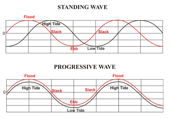
                    The relationship between the times of high/low tide and the times of slack water or maximum current is not a simple one. There are three "base case" conditions. The first is a "standing wave" type of current. In a standing wave the times of slack water will be nearly the same time as the high and low tides, with the maximum flood and ebb current occurring mid way between the high and low tides. The second is a "progressive wave" current. In a progressive wave, the maximum flood and ebb will occur around the times of the high and low tides, with the slack water occurring between the times of high and low tide. The third case is a "hydraulic current". In a hydraulic current, the current is created by the difference in height of the tides at two locations joined by a waterway. The current will be at its maximum flood or ebb when the difference in the two heights are the greatest. The slack water will occur when the height of the tide at the two locations in nearly the same.

                    Hydraulic currents occur at a limited number of locations. Some examples would be:
                    •the Chesapeake and Delaware Canal, which connects the Chesapeake Bay and Delaware Bay
                    •the East River in New York, which connects Long Island Sound to New York Harbor
                    •certain sections of the Intra Coastal Water Way (ICWW)
                    •between barrier islands which create different tidal conditions on opposite sides of the island

                    Progressive currents are most common at the oceanic entrance to many bays and harbor. Standing wave conditions are most common at the head (most inland point) of larger bays and harbors. Most areas of the coast will fall somewhere in between a progressive and standing wave current. [Example (jpg)] The exact relationship between the times of high and low tides and the maximum current or slack water is unique to each location and cannot be determined from a generic "rule of thumb".

                    Because the tidal currents are created by the same forces which cause the tides, the currents can be predicted in much the same way as the tides. Observational data on the currents at a location can be analyzed using the same methods employed to analyze tides, and the results of that analysis can be used to generate predictions of tidal currents. However, because the relationship between tides and tidal currents is unique to each location, tide predictions and tidal current predictions are generated separately.
                    Tide predictions provide the times and heights of the tides.
                    Tidal current predictions provide the times and speed of maximum current and times of slack water.

                    It is up to the user to insure that they are using the correct type of predictions for their activities.

                    Tide Info: http://www.saltwatertides.com/pickpred.html

                    Comment


                    • #11
                      Here is the updated link for MD Public Boat Ramps:

                      http://dnr.maryland.gov/Boating/Page...boatramps.aspx
                      "Fish on a Dish" - 2017 Jackson Big Tuna
                      Jackson Cuda 12

                      Comment


                      • #12
                        The link for "MARYLAND PUBLIC LAUNCH SITE" still has not been updated, at least not on my computer. When I click on MARYLAND PUBLIC LAUNCH SITE on the Snaggedline Sticky it takes me deep into Maryland Fisheries/Boating LA-LA Land. The link should be:

                        http://dnr.maryland.gov/boating/page...boatramps.aspx

                        The same as what nhunter344 suggested nearly a year ago.

                        Come on Administration. Make it easy for the newbies... and the oldbies like me to find the correct link. Thanks
                        Howard

                        16' Oldtown Camper Canoe with a side-mount 40# thrust trolling motor.

                        Comment


                        • #13
                          Thanks for updating the site in a timely fashion. Howard
                          Howard

                          16' Oldtown Camper Canoe with a side-mount 40# thrust trolling motor.

                          Comment


                          • #14
                            Are these your posts?
                            Thanks
                            Canada Games

                            Comment


                            • #15
                              I'm very leary of the above post and affiliate link. I wouldn't click on it. Admin? Redfish12
                              Tight lines
                              Hobie Ivory Dune Outback
                              Hobie Caribbean Blue Sport
                              Wilderness Red Tsunami 145
                              Wilderness Green "Warhorse" Tarpon 160

                              Comment

                              Working...
                              X