Announcement

Collapse
No announcement yet.

Potomac Dams....Where are they?

Collapse
X
 
  • Filter
  • Time
  • Show
Clear All
new posts

  • Potomac Dams....Where are they?

    Search the maps for the Potomac dams and i couldn't find anything except for 3 and 4? Being ignorant for a decade I havent Venture out in the to the "Piedmont" Potomac. Currently i live in Montgomery County. So it's a 30mins drive for me! I'm so stupid! Thanks for any info!

  • #2
    see follow up post below.
    Last edited by bignose; 01-18-2014, 03:01 PM.

    Comment


    • #3
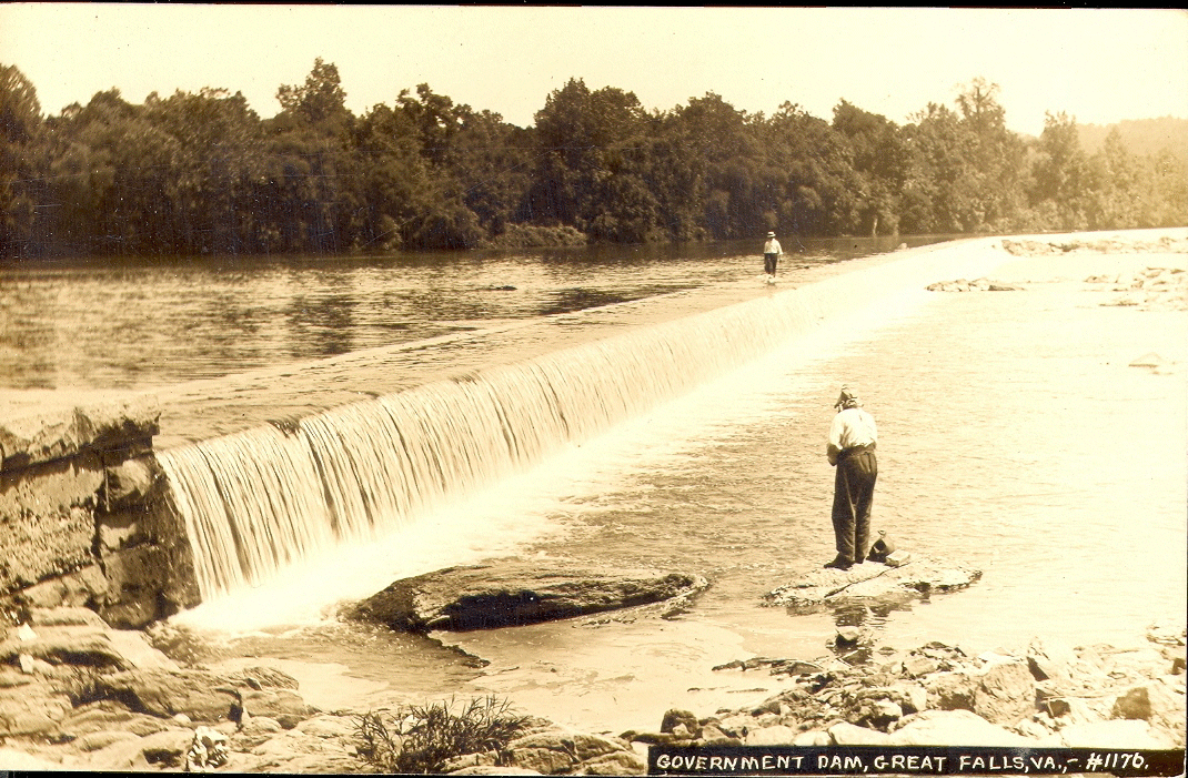
      There is also the Great Falls dam just below Conn Island. It used to be known as Government Dam.

      Comment


      • #4
        I just finished a little Goggle research
        I accessed the USGS file entitled: "Geology of the Chesapeake and Ohio Canal National Historical Park

        It is a very complete and lengthy file to download, but it is fascinating read.

        According to this file:
        Dam #1 the Little Falls Dam was constructed in 1750
        Dam #2 at the Seneca Breaks 1828, this is now a pile of rubble above the Breaks
        Dam #3 above Harpers Ferry 1879, this is breached in several places
        Dam #4 1832-1834 this is about 4 miles up river from Taylor's Landing, in Washington County
        Dam #5 1833-1835 a couple of miles above Williamsport (corrected previous post-thanks to Capt C-Hawk)
        Dam #6 1839 east of Woodmont Maryland. I can't seem to find this on a map or Google Earth. It was supposed to be just upstream from Great Cacapon VW. There is a Woodmont Rd there.
        Dam #7 near Paw Paw, planned but never constructed
        Dam #8 at Cumberland removed in 1958 for flood control.

        My assumption is that the earliest dams were constructed to provide water for the C&O canal and flood control.
        Many were wood and rubble fill, which didn't survive the flooding.
        Prior to the construction of the C&O canal, the original thought about using the Potomac for the transportation of goods from the mid west was to "remove the rocks from the river".
        The B&O railroad beat the canal construction to Cumberland, but the canal remained in service thru about 1924.
        There were huge floods then and in 1936.

        There are other dams on the Potomac, not a part of the canal system.
        Last edited by bignose; 01-20-2014, 05:12 PM.

        Comment


        • #5
          The Little Falls dam isn't the Government Dam. Little Falls is about 8 miles downstream of it.


          https://archive.org/details/TheHisto...allsMarylandBy


          Comment


          • #6
            Is this the Washington Aqueduct Dam, just above Great Falls?
            The report wasn't clear about this, but I do remember the proximity of Conn Island as shown. I am not sure if this was a part of the original Canal Dams.
            Thanks for the correction.

            Comment


            • #7
              Yeah


              The first part from MD to Conn Island was completed in 1867. Later they wanted more water and extended it to VA, completed in 1886.

              Comment


              • #8
                Dam 5 is several miles above Williamsport, also known as Honeywood Dam. It holds back 20' of water in an area known as Big Slackwater. The next dam downstream is at the powerplant at Williamsport. This dam is not numbered. There's a park above the dam with a boat ramp and a beach. This is where Conococheague Creek enters the Potomac. The next dm is #4.

                Comment


                • #9
                  Thanks for the additional information!
                  Post above corrected.
                  I guess that the USGS article only mentioned the Dams relevant to the C&O canal.

                  Comment


                  • #10
                    Big Slack water is actually above Dam 4 as the area of slack water is about twice that above Dam #5. I live really close to Taylor's Landing boat ramp, if anyone comes up fishing in the area.
                    Big Slack Water
                    "If you can't have fun doing it, it ain't worth doing." ... or you're just doing it wrong.

                    My Blog "Confessions of a fisherman, hunter and tinkerer"

                    Comment


                    • #11
                      Originally posted by archeryrob View Post
                      Big Slack water is actually above Dam 4 as the area of slack water is about twice that above Dam #5. I live really close to Taylor's Landing boat ramp, if anyone comes up fishing in the area.
                      Big Slack Water
                      I took my son caving a few years ago near Dam#4. We made a fire by the water and cooked lunch...the whole time kicking myself not bringing a fishing rod. Such a beautiful area and looks like a smallmouth paradise
                      2015 OLIVE HOBIE OUTBACK
                      2013 OLIVE HOBIE OUTBACK
                      2013 OCEAN KAYAK TRIDENT 13


                      JEREMY D

                      Comment


                      • #12
                        The dam near Harpers Ferry used to divert water for armament production at Harpers Ferry. The lock and doors are still in place on the West Virginia side of the river. It is part of the park. That is also a good place to go wade fishing.

                        The remnants of the dam still provides a back water flat area to fish. It is like a large elongated lake. I fish the Knoxville area and above. The ramps are along the C&O.

                        Comment


                        • #13
                          The elongated lake is accessible from the Dargen boat ramp, but you have to deal with boats. Up stream from the Dargen Ramp is a long rock break forming and island. Fishing can be awesome right there. When the water is low boats can't get up the shoot on the WVA side, but you can drag up the right side and fish the slow spot above where boats can't get to, unless they have a dock in there. I'd do a float from Antietam to Dargen 1/2 Day or Shepardstown to Dargen all day if anyone is interested.

                          You can access Harpers Ferry for wading at Keep Tryst road but it sucks for kayaks there. The trail is up and down, washed out, trees over and will knock the kayak off the kart. Its like a portage spot, Two guys and pick up and carry the kayaks a lot!! You need a 10' rope on the front of your kayak with a clip to get out and wade all the time like Dave (Turtle) does. They show sandy Hook as a launch under the 340 bridge, but I have never seen anywhere you can park there. That road is narrow!! The turn in Harper's Ferry Road has a launch but you have to park down the road after you unload and pull out downstream some where. Paddling back up would be hard!

                          The old Dam 3 current can be pretty quick and all the old rocks make your kayak like the ball in a pin ball game. Its kind a cool place to hike and get a look around. Accessible from the Lock 34 parking area. Lots of big old rounds dam rocks on the sides out of the main current where you can hop around. The view from over the Railroad tunnel on the MD side is awesome. If you have never done it, you should!!
                          Last edited by archeryrob; 01-21-2014, 05:53 AM.
                          "If you can't have fun doing it, it ain't worth doing." ... or you're just doing it wrong.

                          My Blog "Confessions of a fisherman, hunter and tinkerer"

                          Comment


                          • #14
                            Here is a link to Potomac River Guide. The website has interactive maps and such. Might be helpful.

                            http://www.riverexplorer.com/

                            Comment


                            • #15
                              I know that rocky island area well. That area for about two miles down stream can be great fishing. It takes some time to find the deep holes and rocky points, but it is a fun place to fish.

                              Comment

                              Working...
                              X