Announcement

Collapse
No announcement yet.

Potomac Dams....Where are they?

Collapse
X
 
  • Filter
  • Time
  • Show
Clear All
new posts

  • #16
    My favorite area to fish in Maryland is the area between Dam 4 and Taylor's Landing.
    I also enjoy the stretch up river from the Brunswick Ramp.
    Does anyone know if the Brunswick Campgrounds has become public?
    Several years ago I went to launch there and a campground employee ran me off.
    I had launched there and wet waded there several times.

    There are two good references to the area:
    Ked Penrod's guide to the Upper Potomac River is dated but the info is still valid. Some of the buildings are no longer there (his cabin in Lander washed out about 20 years ago). How much could the ledges and holes he mentioned move?
    Also:
    Edward Gertler's Guide to Maryland and Delaware Canoe Trails
    give extensive descriptions of the Potomac, albeit from a white water enthusiasts point of view.
    Last edited by bignose; 01-20-2014, 06:23 PM.

    Comment


    • #17
      Originally posted by archeryrob View Post
      The elongated lake is accessible from the Dargen boat ramp, but you have to deal with boats. Up stream from the Dargen Ramp is a long rock break forming and island. Fishing can be awesome right there. When the water is low boats can't get up the shoot on the WVA side, but you can drag up the right side and fish the slow spot above where boats can't get to, unless they have a dock in there. I'd do a float from Antietam to Dargen 1/2 Day or Shepardstown to Dargen all day if anyone is interested.

      You can access Harpers Ferry for wading at Keep Tryst road but it sucks for kayaks there. The trail is up and down, washed out, trees over and will knock the kayak off the kart. Its like a portage spot, Two guys and pick up and carry the kayaks a lot!! You need a 10' rope on the front of your kayak with a clip to get out and wade all the time like Dave (Turtle) does. They show sandy Hook as a launch under the 340 bridge, but I have never seen anywhere you can park there. That road is narrow!! The turn in Harper's Ferry Road has a launch but you have to park down the road after you unload and pull out downstream some where. Paddling back up would be hard!

      The old Dam 3 current can be pretty quick and all the old rocks make your kayak like the ball in a pin ball game. Its kind a cool place to hike and get your feet feet. Accessible from the Lock 34 parking area. Lots of big old rounds dam rocks on the sides out of the main current where you can hop around. The view from over the Railroad tunnel on the MD side is awesome. If you have never done it, you should!!
      Thanks for the information and tips. Been to Dargen but never headed up river and them rocks sure look fishy. May take you up on the float trip in the spring.
      How is the launch at Antietam? Hike involved? You launch into the creek? I can't make out much from Google Earth or Maps.

      Comment


      • #18
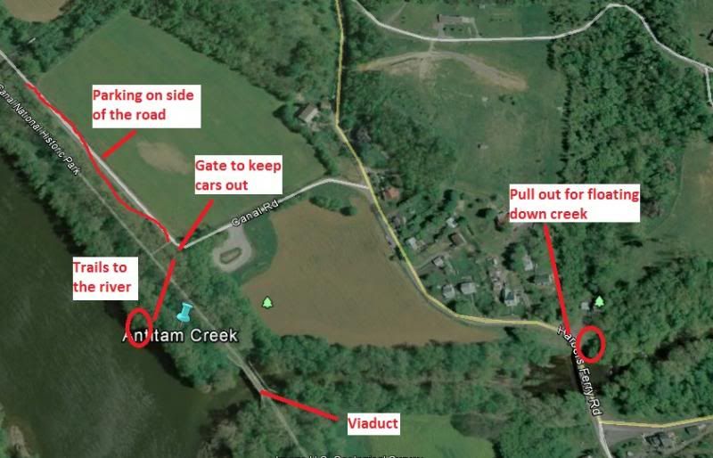
        Here is how you can launch at Antietam as there is not defined ramp. You park along the road as you come down from Rt 34 Shepardstown Pike. All the hikers and everyone else does, its part of the park service and they expect you to do it. From the road you cam portage or cart down the road, through the gates open for hikers, across the land bridge for the canal and you will see trails to the river between the land bridge and Viaduct (Canal Water Bridge) over Antietam creek.

        You can also pull out at the red circle at the stone bridge that crosses the Antietam. We usually use this spot when floating the Antietam for fishing. You just can't park here and you can't paddle up the creek, you have to get out and pull the kayak with a rope. The trails of the canal will be the easiest for you to use.

        Last edited by archeryrob; 01-21-2014, 07:25 AM.
        "If you can't have fun doing it, it ain't worth doing." ... or you're just doing it wrong.

        My Blog "Confessions of a fisherman, hunter and tinkerer"

        Comment


        • #19
          This picture should be better. Photobucket keeps showing me the old picture.

          Antietam Creek.jpg

          Bignose, give me a shout when you fish that area.
          "If you can't have fun doing it, it ain't worth doing." ... or you're just doing it wrong.

          My Blog "Confessions of a fisherman, hunter and tinkerer"

          Comment


          • #20
            Originally posted by archeryrob View Post
            Here is how you can launch at Antietam as there is not defined ramp.
            Thanks, very helpful. Will save me a scouting trip

            Comment


            • #21
              Originally posted by bignose View Post
              My favorite area to fish in Maryland is the area between Dam 4 and Taylor's Landing.
              I also enjoy the stretch up river from the Brunswick Ramp.
              Does anyone know if the Brunswick Campgrounds has become public?
              Several years ago I went to launch there and a campground employee ran me off.
              I had launched there and wet waded there several times.

              There are two good references to the area:
              Ked Penrod's guide to the Upper Potomac River is dated but the info is still valid. Some of the buildings are no longer there (his cabin in Lander washed out about 20 years ago). How much could the ledges and holes he mentioned move?
              Also:
              Edward Gertler's Guide to Maryland and Delaware Canoe Trails
              give extensive descriptions of the Potomac, albeit from a white water enthusiasts point of view.
              Upriver from Brunswick is Knoxville falls , correct. How dicey is that?

              The Da4 to Taylor's is known for Walleye. Have you caught them regularly in that section. Where do you out in at dam 4. In W Va. at the base of the dam?
              Hurricane Skimmer 128
              WS Pamlico 100

              Comment


              • #22
                The "three ledges" at Knoxville isn't too dicey. Most of the time, I'll get out and drag the kayak over the rocks for the first two ledges. As for the third ledge, if you don't feel like dragging over, you can run the MD side. Fairly clear of rocks and it moves a good amount of water. Just keep your speed up.

                Comment


                • #23
                  I have very occasionally caught a few walleye in some of the deeper holes below Shepherd's Island. Deep running crank baits and curly tailed jigs. I do better for walleye over on the Susky.
                  Usually I'm fishing for Smallies.
                  While it is possible to put in below Dam #4 and float down to Taylor's Landing, that involves setting up a shuttle.
                  I prefer to launch at the upper ramp at Taylors Landing (there are 2 ramps split by a ledge) and motor upstream to just above Shepherd's Island and drift down.
                  My "Kayak" is an Old Town Canoe with a 55 lb. thrust electric motor.

                  Knoxville Falls is about 4 miles up from the Brunswick Ramp.
                  Everything depends upon water level.
                  I generally only fish in warm weather with relatively low summer flows. I have used my electric motorized canoe to go up that far only once or twice. I'll usually stop at the Brunswick Islands which are, perhaps, 2 miles upstream from the ramp.
                  A safe level is under 1.5 feet at the Point of Rocks Ramp on the USGS gauge. 2.0 feet is the caution level, there.
                  At that level, there is a strong current out of the Brunswick ramp on the Maryland side, but after the first 100 yards out under the bridge or so, it slows a good bit. Still, it would be a lot of work to paddle or peddle that far upstream against the current.

                  My first couple of times fishing this area involved wet wading out from the Brunswick campgrounds. The water level was extremely low and I was actually able to wade across to the Virginia side. I was a lot younger, then!
                  There were several riffles that I have had to pole my canoe thru during summer drought conditions.
                  There have also been times when I have driven up there, taken one look at the water and gotten back in my car due to high flow (dumbass me didn't check the gauge!).
                  The Shenandoah often pumps a good bit of water into the river at Harper's Ferry. If there is heavy rain in it's drainage, there can be a mud line all the way down to Brunswick.
                  Last edited by bignose; 01-21-2014, 01:11 PM.

                  Comment


                  • #24
                    Its been years since I last canoed the Harpers Ferry to Point of Rocks section. I use to fish this area a lot back in the '70s -'90s. Not the whole area at once but I'd do all the sections in turn between ramps within this length of river. I'm a slow fishermen when out in a canoe.

                    I've canoed thru the breach in the Harpers Ferry Dam (Dam #3) several times with no problem and would paddle on down river and take-out at the Brunswick ramp. I'd do this section at or near summer low flow. Several times I'd have rank amateurs in the front seat. No fishing gear when doing this section, just having some whitewater fun. This whole area you really need to be on your toes because there's pretty much one rapids after another all the way to Brunswick. Most of them are easy to get thru with lots of good pools between rapids to rest and recover.

                    Danger spots are White Horse Rapids located a couple 100 yards above Rt 340 and Knoxville Falls located between Rt 340 and Brunswick. Both of these rapids have swamped many a novice canoer/kayaker. White Horse is famous for it's standing waves known as haystacks. But if you approach both of these rapids with care you can get thru. Both rapids can be viewed and scouted up close from shore on the Maryland side. C&O Canal tourist and hikers frequently stop at White Horse to watch the kayakers surf back and forth in between the hay stacks. I have never swamped in this area... but then I don't play in the stacks either.
                    =======================
                    Started snowing here before sun-up and as of 10:00am this morning I have 1" of new snow on the ground and its coming down heavy!!!
                    Howard

                    16' Oldtown Camper Canoe with a side-mount 40# thrust trolling motor.

                    Comment


                    • #25
                      Really appreciate all the information on this thread. I'm putting together a Google Earth file of all the launches on the Potomac if anybody is interested let me know, Ill share it with Dropbox, email or something

                      Comment


                      • #26
                        What is interesting about Goggle Earth or Bing maps is that they are using a composite of many images, often taken at various river stages, and during different seasons.
                        Going few hundred yards and the river can be at summer low flow next to a spring flood stage!

                        Comment


                        • #27
                          Originally posted by DonV View Post
                          Really appreciate all the information on this thread. I'm putting together a Google Earth file of all the launches on the Potomac if anybody is interested let me know, Ill share it with Dropbox, email or something
                          The below link from the Potomac river guide site, which I listed earlier in this thread, shows an interactive map listing 132 boat ramps and kayak access points.
                          http://www.riverexplorer.com/boat_ramp_map.php4

                          Comment


                          • #28
                            Thanks, that is what I'm already using to pull the information from. I like having the Google Earth file as I can easily export to my FF/GPS or Auto/GPS. Once again when I get it done anyone is welcome to it.

                            Comment


                            • #29
                              Doing my research on the Potomac inspired by this thread, I found a nice kmz. file of the C&O trail with all the mile markers, water,boat ramps, campsites, parking etc.
                              Go tohttp://www.tasigh.org/kmz/ and grab the C&O canal.kmz file. It seems to be dead on and would have saved me a lot of manual work and guessing. Having the trail mile markers is very handy and should help anyone planning on fishing the Potomac.

                              Comment

                              Working...
                              X